

The Mayan proto-genesis monument at Aguada Fénix flashed into the modern world in 2017 when LiDAR pierced the jungle veil. Scientists were scanning southeastern Mexico for modest villages. But a colossal plateau appeared across their screens instead. The structure ran 1.4 kilometers long and towered up to 15 meters high. From dead center, raised walkways and deep channels radiated outward in four flawless directions. The complete pattern carved a cross 9 kilometers east to west and 7.5 kilometers north to south. While no pyramids broke the skyline, the ground itself spoke the cosmos.
Lasers Strip Away Centuries
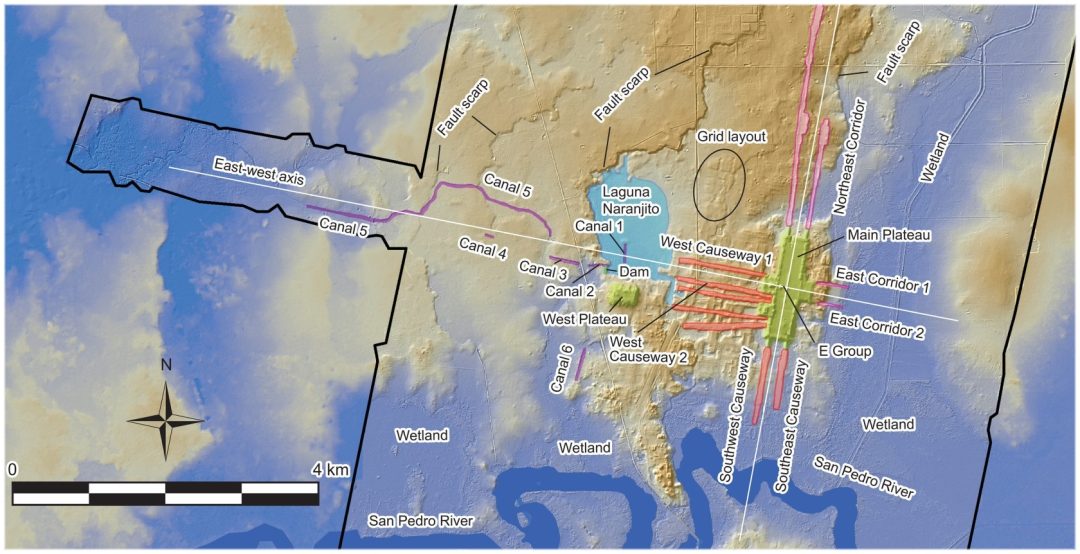
Flight teams from the National Center for Airborne Laser Mapping captured the first images in 2017. Followed by Mexico’s national geography institute which added more data. Together the scans erased trees and topsoil to expose raw earth. A central plateau, largest ever discovered in Mayan construction, locked everything in place. Elevated causeways and Sunken corridors dropped below ground. The longest corridor pushed 6.3 kilometers northwest. West of a natural lake named Laguna Naranjito stood a massive dam with canals up to 35 meters wide and 5 meters deep. Every line stayed within two degrees of true cardinal points.
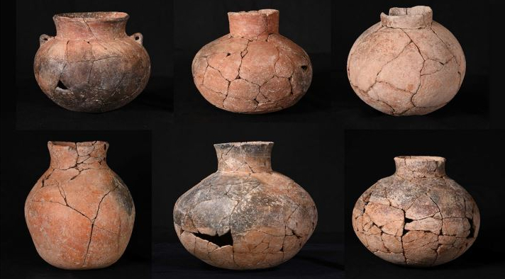
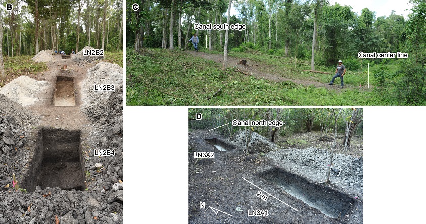
Ground crews landed in 2020. They unearthed charcoal and bone which dated the main construction between 1050 and 750 BCE. Ceramics dated to 1200 BCE pushed the earliest occupation back further. Workers started by mounding earth over the lowest northern and southern terrain raising the plateau in careful stages
Sky Stage
At the plateau’s core were two low western mounds, opposite a long eastern platform, across an open plaza. They found the east-west axis of the monumental earthworks aligned with the rising sun on October 17 and February 24. Those dates sat 130 days apart, half the 260-day ritual cycle that would rule Maya time for millennia.
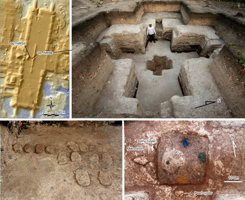
Excavators uncovered two cross-shaped pits sliced to bedrock beneath the plaza. One centered and subset into the other. The outer cross spanned nearly 6 meters each way. Builders lined the walls with white clay and kept the space open for ceremonies. Two dozen unbaked clay axes lay at the bottom of the large pit. Red ochre colored some of these artifacts. The inner pit held black clay painted with directional pigments. Blue faced north. Green marked east. Yellow pointed south. A hollow opened to the west. Marine shells were found surrounding the clay form. Pearl oyster rested south. Atlantic conch and spiny oyster faced west. These ocean offerings pulled distant seas into local earth and fixed colors to the world’s four corners.
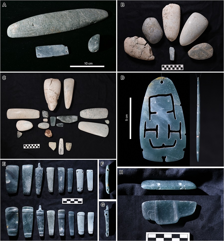
Later deposits stacked above the first pit in the same cross layout. Greenstone artifacts (Serpentine, Jadeite, or Chlorite) appeared in deliberate layers. One offering arranged eighteen small axes into four arms and a center. Another included a crocodile carving, a bird pendant, and a thin jade plaque that may depict a woman giving birth. Every greenstone item belonged to the public plaza.
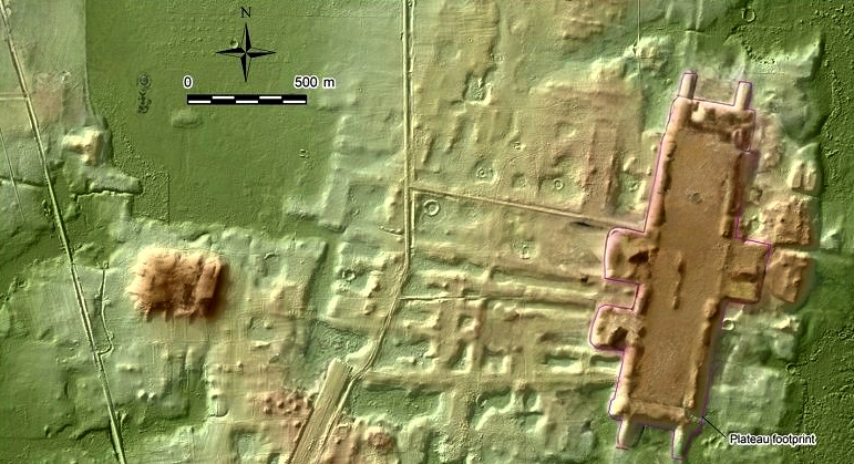
Scans across 100 square kilometers found no palaces or tombs. Leading researchers to surmise this was a communal ceremonial site.
Water That Carries the Cosmos
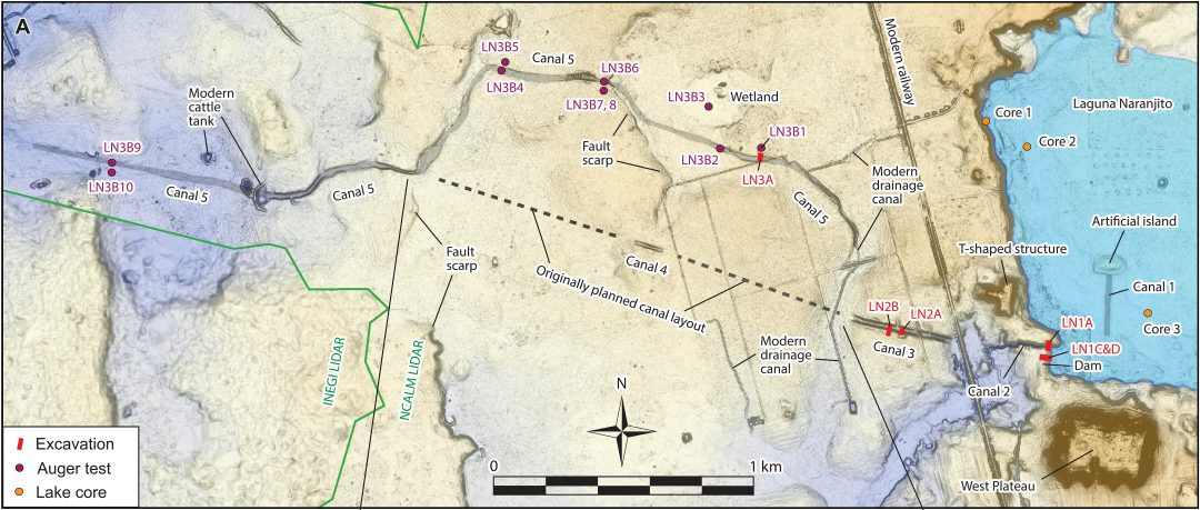
Laguna Naranjito was originally a natural lake. Local residents told the team it once held deeper water, before modern deforestation and siltation dried it out. Researchers discovered the Ancient builders dammed its southwest shore with a wall 120 meters long and up to 55 meters wide. They packed it with toolmaking waste, limestone cobbles, and black lake clay. They also found two stone blocks at the northern end of the dam that they believe once supported a sluice gate.
Six canals reached west from the dam. The longest stretched 1.5 kilometers. Workers sliced through limestone and piled the spoil into berms. The builders dug the canal floors 1.3 meters below the lakes dry season water level. This allowed water to flow, even during the dry season, into the canals on gravity alone.
Fish bones and pottery on the dam dated feasts to 930–820 BCE. Steady water fed thousands for drink, food, and cleansing. But the network of canals was never finished. A 120-meter test cut at the highest ridge captured the moment surveyors realized solid bedrock blocked any straight western extension.
The Calendar Older Than Writing
Daykeepers had established 260 day calendar generations before a single glyph appeared. Oral memory and sunrise observation carried the count across centuries. The first written day names show up around 300 BCE at San Bartolo; 750 years after Aguada Fénix rose. Numerical bars and dots arrive even later, 600–400 BCE. Here the calendar stood in earth and water long before anyone thought to record it on bark or stone.
Planning on an Immense Scale
No royal marker exists anywhere. Yet the precision demands meticulous design. Lines held cardinal alignment across faulted ground. The central cross pit sat exactly beneath the solar observation point. Canals followed the east-west axis within engineered gradients. The 120-meter test cut at the upland crest proves surveyors measured elevation before committing labor. The entire 9-kilometer cosmogram required coordination that rivaled later empires.
Mayan Proto-Genesis Monuments Story
People shifted earth with stone tools and woven baskets. They raised millions of cubic meters yet left no sign of forced work. When bedrock ended the canals around 700 BCE, the center quieted. The same pottery and rituals soon bloomed 50 kilometers west at Nixtun-Ch’ich’, where a fresh grid and sky-watching arrangement rose.
The plateau dwarfs every other structure in the Maya region for centuries. The complete Mayan proto-genesis monument covers ground equal to later cities like Tikal or Teotihuacan. Olmec sites raised smaller platforms and topped them with thrones and ruler faces. Aguada Fénix carries shows no signed of similar veneration. Greenstone and ocean shells serve only as offerings to the shared center.
Mobile communities carried oral knowledge of the 260-day count across generations. Daykeepers watched the sun long before anyone carved a glyph. At Aguada Fénix they poured that ancient memory into soil and water. The Mayan proto-genesis monument became the first built version of their cosmos, a place where time walked the causeways, water spoke the directions, and thousands met beneath open sky. When the land set limits, they listened and took the vision forward.
Chronology and Abandonment
Aguada Fénix was occupied for roughly 350 years. The site was abandoned around 700 BCE. Later groups returned during the Terminal Preclassic and Late Classic periods. They built a mound on the southern edge of Canal 3. Ceramics from this period were found in canal fills. These deposits suggest post-abandonment activity.
The original builders may have used the site seasonally. The orientation of the E Group matches the dry-season sunrise. The northern corridors cross wetlands and would be impassable during rains. This supports seasonal use tied to calendrical events.
Conclusion
The oldest Mayan ruin at Aguada Fénix demonstrates large-scale construction, calendrical alignment and symbolic planning. Its cruciform cosmogram spans nearly ten kilometers. The site includes ritual caches, directional pigments, marine shells and unfinished canals. These features reflect deliberate design and coordinated labor.
The builders organized massive projects with calendrical precision. The evidence supports complex planning and symbolic coherence. The oldest Mayan ruin stands as a monumental expression of early Mesoamerican vision and capability.
Like this story? Check out The Codex Grolier: A Window into the Maya’s Lost World