

Alexander the Great founded dozens of cities across his vast empire but few have captured the imagination quite like Charax Spasinou. Once a thriving metropolis on the banks of the Tigris and Eulaeus rivers in southern Iraq near modern Basra this ancient harbor town served as a vital link in global trade routes connecting India Babylonia and the Mediterranean. Founded as Alexandria it endured repeated floods destruction and rebirth only to vanish beneath silt and sand for centuries. Recent archaeological projects have brought it back to light using cutting edge technology that reveals not just the city’s physical remains but its complex history as a multiphase urban center. Through drone surveys magnetometer mapping and targeted excavations researchers are piecing together the story of this remarkable site.
Historical Background
The citys origins trace back to the ambitions of Alexander the Great who established it as Alexandria on the Tigris. After destruction by flooding it was refounded in 166 or 165 BC by the Seleucid king Antiochos IV and renamed Antiochia. Further floods led to yet another rebirth under the local ruler Hyspaosines who named it Charax Spasinou meaning the palisade of Hyspaosines. This final incarnation flourished as the capital of the kingdom of Characene.
Its strategic location at the head of the Persian Gulf transformed it into a major port and trading hub. Goods from India such as spices perfumes ivory and semi precious stones arrived by sea while caravans from Petra and Palmyra brought frankincense myrrh and other luxuries. Chinese envoys even passed through on their way toward Rome. The city remained prosperous under Parthian influence with its own mint producing coins and a diverse population that included traders merchants and residents from across the known world. Yet repeated flooding and eventual silting of the river channels eventually caused its decline and abandonment.
Rediscovering the Site
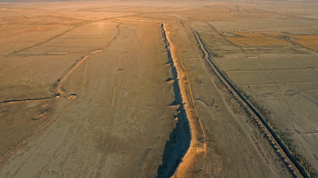
The location of Charax Spasinou was first identified in 1965 when distinctive ramparts rising four to six meters high were documented at the modern site of Jebel Khayaber. In 2016 a collaborative project led by Jane Moon Robert Killick and Stuart Campbell from the University of Manchester along with Stefan Hauser from the University of Konstanz and the Iraqi State Board for Antiquities and Heritage began systematic investigations.
The goals included mapping the city layout determining its chronology assessing preservation and planning for future conservation. Challenges were significant: the site spans roughly five square kilometers much of it obscured by flooding erosion agricultural activity and remnants of the Iraq Iran war. Despite these obstacles the team employed non invasive methods to explore without disturbing the buried remains
Mapping from Above with Drone Technology
One of the first steps involved aerial mapping using a small drone flown in a grid pattern at one hundred meters altitude. This effort covered nearly twelve square kilometers producing thousands of overlapping photographs. Processed with photogrammetry software these images created detailed digital elevation models orthomosaics and topographic maps with a resolution of about four centimeters per pixel.
The drone data highlighted the massive ramparts still visible in the north and east extending over two point four kilometers and one point one kilometers respectively. It also revealed surface features such as salt deposits that outline buried structures after rain due to varying evaporation rates above and between walls. This birdseye view provided the essential framework for understanding the modern landscape and guided ground-based investigations.
Revealing the City Below the Surface through Geophysical Surveys
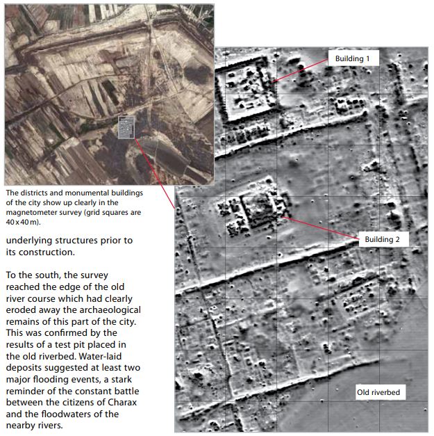
To peer beneath the salinated soil the team conducted extensive magnetometer surveys. In 2016 Jorg Fassbinder and his team from Ludwig Maximilians University used a caesium magnetometer in duo sensor configuration covering nearly ten hectares. Subsequent seasons from 2017 to 2018 employed Bartington fluxgate gradiometers expanding the surveyed area to almost ninety hectares total.
These instruments detected subtle variations in the earths magnetic field caused by buried mud brick walls baked brick structures and other features. The results were remarkable showing a clear urban grid in the city center with streets following a Hippodamian plan. City blocks measured approximately one hundred sixty one meters by eighty eight meters among the largest known from the ancient world.
Monumental buildings including possible temples palaces and residential quarters appeared alongside a central north south street or canal up to twenty five meters wide. The surveys also confirmed that the southern portion of the city had been heavily eroded by the ancient Karun River but some settlement survived beyond the visible riverbed. Overall the data suggest a total city area of around seven hundred hectares though well preserved archaeology covers only about one hundred fifty hectares.
Excavations Artifacts and Urban Features
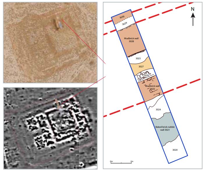
Evaluation trenches dug at key locations confirmed the geophysical findings. Trenches across two monumental buildings revealed walls on alignments predicted by the magnetometer data one with a central courtyard on a mud brick platform and perimeter walls of baked brick the other with mud brick exteriors and a baked brick paved courtyard.
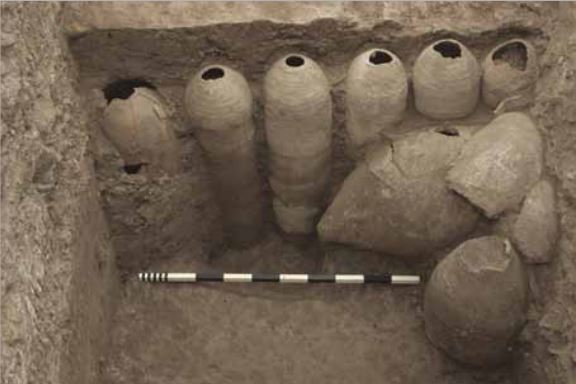
A linear feature marking the boundary between city blocks proved to be a ditch flanked by parallel walls. Along its southern side excavators uncovered nearly a dozen large storage jars over a meter long set upside down in a row their bases neatly cut off. Originally used for storing liquids like wine and lined with bitumen these jars may have served a secondary purpose perhaps related to drainage though their exact function remains a puzzle. The ditch also contained broken pottery animal bones mostly from young sheep and goats and other household refuse indicating nearby residents enjoyed a comfortable diet.
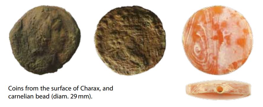
Surface finds included corroded coins some in Seleucid style others depicting later rulers a beautiful carnelian bead glass vessels including a mosaic cube fragments of decorated stone and columns. Luxury pottery with originally brilliant green glazes found in quantity suggests local workshops produced high quality wares traded across the Gulf region.
Interpreting a Multiphase Urban Landscape
The magnetometer data reveal a city that evolved over time rather than adhering to a single rigid plan. While the main east west streets maintain regular spacing the north south streets show irregularities to the west possibly due to long term modifications or initial variations in planning.
Multiple building phases are evident through overlapping structures different orientations and areas of leveled ground. For instance one building intersects earlier walls while another sits atop removed and leveled earlier construction. Certain structures display higher densities of magnetic anomalies hinting at specialized functions such as a possible macellum or market hall with a distinctive round inner structure surrounded by small rooms.
Thermoremanent signals indicate a sophisticated drainage system beneath east west streets using reused storage jars. This infrastructure underscores the high level of urban investment and the need for resilience against repeated flooding.
A Cosmopolitan Trade Hub and Its Legacy
At its peak Charax Spasinou embodied the cosmopolitan spirit of Alexander the Greats vision. Markets and harbors bustled with merchants from India, Petra, Palmyra and beyond exchanging silks cotton spices and luxury goods. The citys own coinage and fleet supported its role as a nexus of international commerce even as it navigated shifting political control between Seleucids Parthians and local dynasts.
Archaeological evidence from coins glass pottery and architectural fragments reflects the wealth and cultural diversity that once defined it. Though flooding and river silting ultimately led to its abandonment the site offers invaluable insights into Hellenistic urbanism trade networks and adaptation to environmental challenges in the ancient Near East.
Looking Ahead
The investigations at Charax Spasinou demonstrate how modern technologies like drone photogrammetry and magnetometer surveys can unlock the secrets of a long lost city without extensive disturbance. What has emerged so far is a coherent picture of a planned yet adaptable urban center with monumental architecture residential quarters and advanced infrastructure.
Future work including expanded excavations and further remote sensing will deepen our understanding of its chronology preservation needs and role in ancient globalization. As conservation efforts continue this Alexandrian foundation stands as a testament to human ingenuity perseverance and the enduring power of archaeological discovery to reconnect us with the past.