

In the rapidly evolving field of archaeological remote sensing, Synthetic Aperture Radar (SAR) has proven its worth as a reliable, noninvasive reconnaissance tool capable of revealing subtle surface and near surface contrasts across vast landscapes. A recent peer reviewed study published in Acta Geophysica (2026) exemplifies this disciplined application at the multilayered settlement of Buto (Tell el Fara’in) in Egypt’s northwestern Nile Delta, where researchers integrated freely available Sentinel 1 C band SAR imagery with targeted electrical resistivity tomography (ERT) and controlled excavation to confirm a Saite period mudbrick structure resting on an artificial sand foundation.
This multi scale approach stands in marked contrast to more speculative interpretations of SAR data elsewhere in Egypt, such as the unverified claims by radar engineer Filippo Biondi regarding a second Sphinx and extensive underground chambers beneath the Pyramid of Khafre. At Buto, SAR served not as a standalone revealer of hidden megastructures but as the essential first step in a rigorous workflow that guided precise geophysical follow up and ultimately produced verifiable archaeological insights, demonstrating how satellite radar truly assists discovery when paired with ground-based verification and scholarly caution.
The Ancient Site of Buto and Its Research Challenges
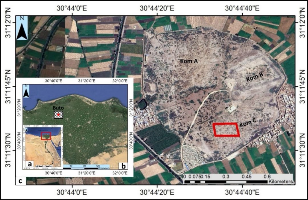
northwest Nile delta; c close-up view of Buto site showing three separate mounds (Koms) and
the investigated area bounded by red rectangle within Kom C Image Source: https://doi.org/10.1007/s11600-026-01809-4
The archaeological site of Buto, located in the flood prone northwestern Nile Delta, comprises three prominent mounds known as Koms A, B, and C, with Kom C selected for detailed investigation due to its complex occupational history spanning the Predynastic period through the Early Islamic era. Successive layers of mudbrick architecture, cultural debris, and alluvial sediments have accumulated over millennia, complicated by Nile branch shifts, seasonal flooding, and later Ptolemaic and Roman disturbances that scattered materials across the upper horizons.
Excavation Challenges
Earlier German missions had mapped broad settlement phases through boreholes, yet the precise location and character of buried features beneath Kom C remained elusive without a cost effective method to survey large areas non invasively. The research team, led by Mohamed A. R. Abouarab and colleagues including Penelope Wilson, recognized that traditional excavation alone would be inefficient in such a waterlogged, clay rich environment, prompting the adoption of satellite SAR as the initial broad scale mapping tool to identify promising anomalies for further study.
This strategic choice of location and methodology addressed key limitations inherent to Delta archaeology, where high soil moisture and salinity reduce the effectiveness of many remote sensing techniques while cultural layers often lie beneath meters of overburden. By focusing on Kom C, the study targeted a zone where Saite period (26th Dynasty, seventh to sixth century BCE) activity was suspected based on prior borehole data showing pottery and structural evidence at intermediate depths. The integration of modern satellite data with established geophysical methods allowed the team to reconstruct paleolandscape features and prioritize excavation targets, thereby minimizing unnecessary disturbance to the site. Such an approach not only preserved the integrity of the tell but also provided a model for future investigations in similarly challenging alluvial settings across Egypt and beyond.
Sentinel 1 SAR Imagery as the Initial Reconnaissance Tool
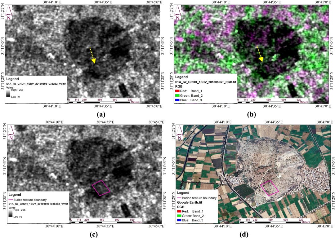
Sentinel 1 C band SAR data acquired on 5 May 2018 in descending orbit with VV polarization were processed in ESA’s SNAP software (version 9.0.0) through a standardized sequence of steps including orbit file application, thermal noise removal, radiometric calibration with multilooking, refined Lee speckle filtering, Range Doppler terrain correction, and conversion to decibels. This workflow produced a clear large-scale image highlighting an oval shaped anomaly approximately 128 by 62 meters in extent, corresponding to subtle dielectric and topographic contrasts likely caused by compacted buried sediments or structures.
Under the dry post-harvest soil conditions typical of early May in the Delta, the C band microwaves achieved limited but useful penetration (roughly 5 centimeters in moist clay and up to 50 centimeters in drier sand), sufficient to flag the anomaly without overclaiming deeper detection capabilities. The SAR results thus served as a reliable guide for selecting ERT survey lines rather than purporting to map intricate subsurface architecture independently.
Truthing of SAR
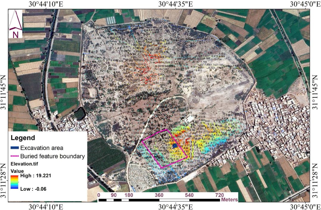
Far from sensationalizing the findings, the researchers explicitly noted the physical constraints of C band SAR in the Nile Delta context and emphasized its role in reconnaissance rather than definitive imaging. By correlating the anomaly with a digital elevation model derived from total station measurements (showing surface elevations around 8 to 9 meters above the buried features), they established that the detected contrast aligned with targets at depths starting approximately 6 meters below the modern surface. This cautious interpretation underscores the proper application of SAR: it narrows vast areas to high priority zones for subsequent higher resolution techniques, ensuring that satellite data enhance rather than replace traditional archaeological methods. The processing transparency and open-source software choice further make the workflow reproducible for other underfunded projects in Egypt and similar environments worldwide.
Electrical Resistivity Tomography for Subsurface Mapping
Fifteen parallel 2D ERT profiles (nine in Group A and six in Group B) were acquired across approximately 5400 square meters on Kom C using a Syscal Pro Switch system in dipole dipole array configuration with 3 meter electrode spacing and full topographic correction from total station GPS data. The resulting inverted models, processed in Res2DInv and Res3DInv software and visualized as both 2D tomograms and full 3D voxel cubes in Oasis Montaj, revealed distinct resistivity contrasts up to 7 meters depth.
The upper 0 to 3 meters displayed diffuse scattered high resistivity anomalies consistent with displaced Ptolemaic or Roman mudbrick fragments, limestone debris, and pottery shards embedded in silty clay. At 3 to 6 meters, a coherent rectangular high resistivity feature (roughly 20 by 25 meters) emerged across multiple depth slices, interpreted as a substantial mudbrick structure from the Saite period, while a uniform high resistivity sand layer at 6 to 7 meters indicated deliberate artificial levelling for foundation stability.
3D ERT
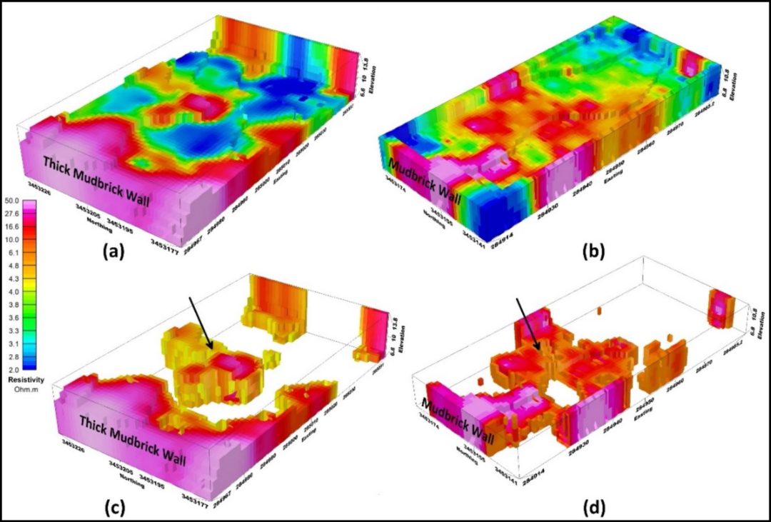
Full 3D inversion proved markedly superior to quasi 3D merging of 2D sections in resolving the geometry and continuity of these features, particularly those aligned perpendicular to the survey lines. This enhanced imaging confirmed the structural integrity of the suspected walls and their relationship to the underlying sand foundation, aligning closely with borehole records from prior German missions that documented Saite deposits 2 to 4 meters thick. The ERT results thus provided the critical bridge between the broad SAR anomaly and the precise excavation targets, demonstrating how resistivity contrasts (higher for drier mudbrick versus lower for wet saline clay) enable reliable differentiation of cultural layers in complex alluvial settings. Such geophysical precision, when combined with SAR guidance, exemplifies the integrated multi scale strategy that transforms remote sensing from speculative mapping into actionable archaeological intelligence.
Excavation as Ground Truthing and Artifact Analysis
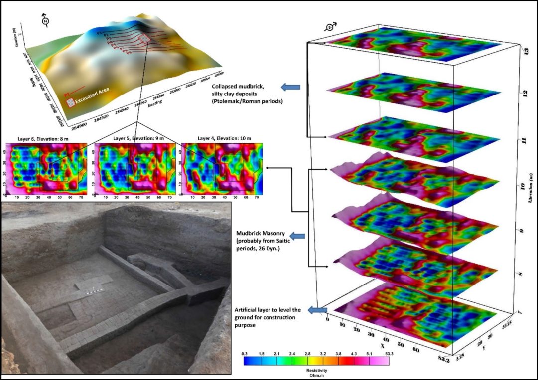
A, along with their potential archaeological interpretation. The profiles’ locations and the excavated area are overlaid on a 3D surface map. Three key resistivity depth slices, shown in section view, highlight significant architectural features, including an approximately 20 m × 25 m structure on the right (dotted rectangles) and another at the top left, the red squares refer to the excavated area. A field photograph provides visual documentation of the archaeological excavation,
revealing wide mudbrick walls and other structural elements Image Source: https://doi.org/10.1007/s11600-026-01809-4
A targeted 10 by 10 meter trench (Square C1) divided into four 5 by 5 meter sub squares was excavated stratigraphically in 10 centimeter spits to validate the SAR and ERT anomalies, revealing six mudbrick walls (W1 to W6) at depths of 3.1 to 4.1 meters with brick dimensions of 22 by 42 to 50 centimeters and wall widths ranging from 55 to 157 centimeters. These architectural elements matched the rectangular high resistivity zones in both location and orientation, confirming the presence of a large Saite period structure possibly functioning as a secondary temple, shrine, or priestly complex.
Artifacts
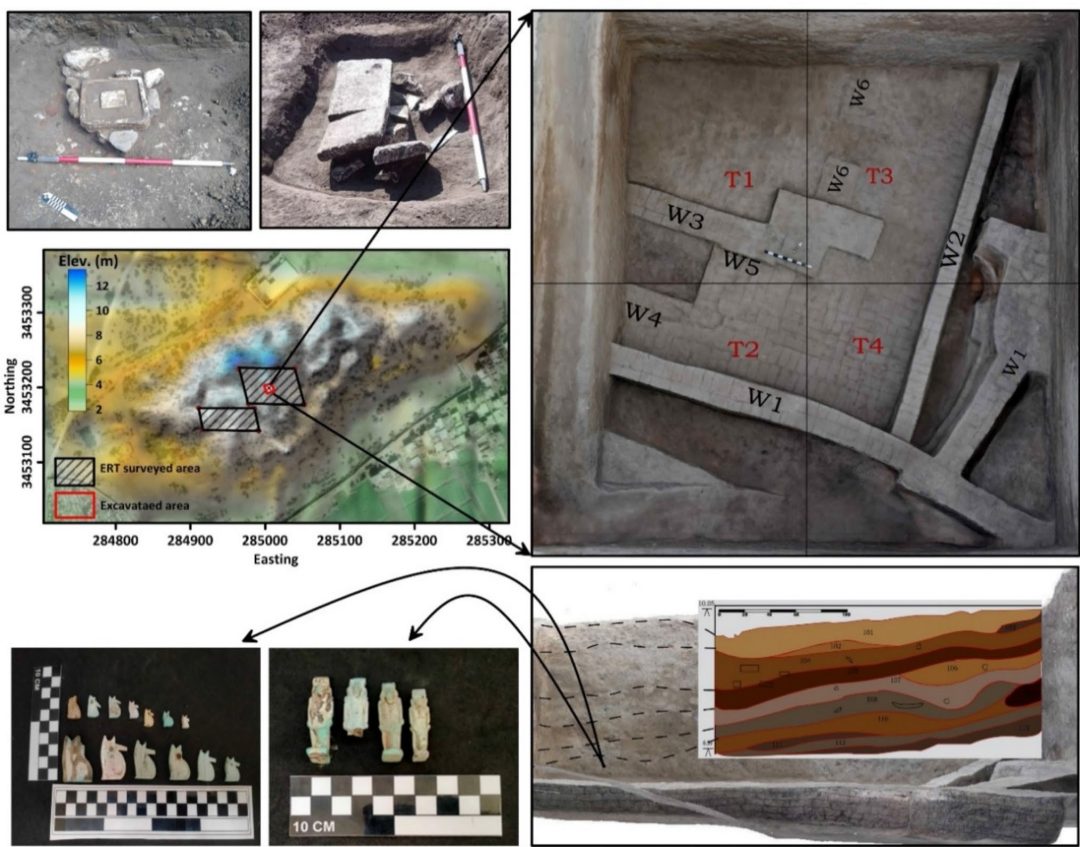
The backfill consisted of compacted clay interspersed with pits containing religious artifacts. Including faience amulets of Isis, Horus, Taweret, Bes, and Wadjet (Buto’s patron goddess), Also a limestone Wadjet amulet, a bronze Horus the Child figure, a steatite scarab inscribed with Thutmose III’s name, and limestone statue fragments, all pointing to strong cultic or funerary associations during the 26th Dynasty.
The excavation depths and material culture aligned precisely with the 3D resistivity depth slices (particularly slices 4 to 6 at elevations 10 to 8 meters), while the artificial sand foundation at greater depth corroborated the ERT evidence of intentional ground levelling. Religious and symbolic finds further reinforced the interpretation of organized Saite period activity at the site, consistent with broader historical records of Buto’s renewed importance after a long abandonment gap. This direct correlation between remote sensing predictions and physical remains illustrates the power of the integrated approach: SAR identified the broad target, ERT refined its subsurface signature, and excavation provided irrefutable confirmation along with cultural context. Such methodical ground truthing ensures that discoveries remain anchored in empirical data rather than untested imagery interpretations.
Contrasting Rigorous SAR Application with Speculative Claims
The Buto study highlights the responsible use of SAR by limiting its claims to surface and shallow subsurface reconnaissance while explicitly acknowledging C band penetration constraints in moist Delta soils, thereby avoiding the overinterpretation seen in other recent Egyptian projects. In contrast, radar engineer Filippo Biondi’s analyses of multi provider SAR Doppler tomography data have proposed a second Sphinx symmetrically positioned opposite the known monument along with extensive underground shafts and chambers beneath the Pyramid of Khafre extending hundreds of meters deep. These assertions, disseminated primarily through podcasts and non peer reviewed channels, lack corroboration from independent geophysical surveys, sediment coring, or excavation and ignore the fundamental physics limiting microwave propagation through dense limestone bedrock to mere centimeters. Without ground based validation, such claims remain speculative despite the impressive volume of processed satellite imagery.
This methodological divergence underscores a broader principle in archaeological remote sensing: SAR excels as a cost effective, all weather reconnaissance tool for large scale anomaly detection but requires fusion with resistivity, magnetic, or seismic methods followed by targeted digging to achieve verifiable results. At Buto, the absence of hype allowed the team to publish transparent, reproducible findings in a respected journal, contributing genuine knowledge about Saite urban planning and religious practices. Biondi’s approach, while innovative in data processing, exemplifies the risks of presenting unverified anomalies as definitive discoveries, potentially eroding public trust in remote sensing techniques. The Buto model thus offers a blueprint for future SAR assisted projects in Egypt, prioritizing integration and verification over sensational headlines.
Conclusion
The Buto investigation demonstrates that SAR, when applied within a multi scale framework combining Sentinel 1 imagery, ERT surveys, and stratigraphic excavation, delivers precise and reliable archaeological insights even in the challenging Nile Delta environment. By guiding the placement of geophysical lines and excavation trenches to confirm a Saite period mudbrick complex with associated religious artifacts, the study not only refines our understanding of Buto’s occupational phases but also validates the practical utility of satellite radar as an assistive rather than conclusive technology. This success story reinforces the value of open source processing tools and peer reviewed publication standards in elevating remote sensing from exploratory mapping to confirmed discovery.
Ultimately, the disciplined methodology at Buto provides a timely counterpoint to more extravagant SAR interpretations elsewhere on the Giza Plateau, reminding researchers and enthusiasts alike that extraordinary claims demand extraordinary evidence through systematic ground truthing. As threats from climate change, agriculture, and urban expansion continue to endanger Egypt’s buried heritage, integrated approaches like this one will become indispensable for efficient, minimally invasive exploration. The Buto project stands as a model of how SAR truly assists archaeological discovery: not by promising hidden megastructures from orbit alone, but by illuminating the path for careful, collaborative science on the ground.