
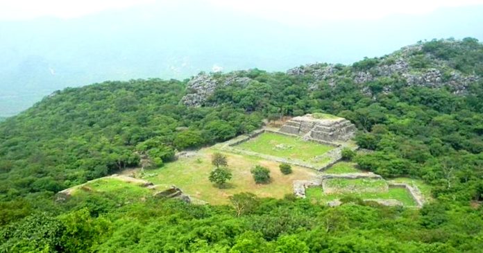
Archaeologists long described Guiengola mainly as the fortified hilltop where Zapotec forces held off Mexica armies in the late fifteenth century. Ethnohistoric sources from the sixteenth century and earlier oral traditions recorded by Francisco de Burgoa reinforced this view of a military stronghold linked to the nearby town of Tehuantepec. New research from the Guiengola Archaeological Project changes that picture. Airborne lidar scans from 2022, paired with systematic pedestrian surveys between 2018 and 2023, document a sprawling urban settlement covering 360 hectares on a plateau in the southern Isthmus of Tehuantepec, Oaxaca.
Mapping the Full Extent with Lidar and Survey
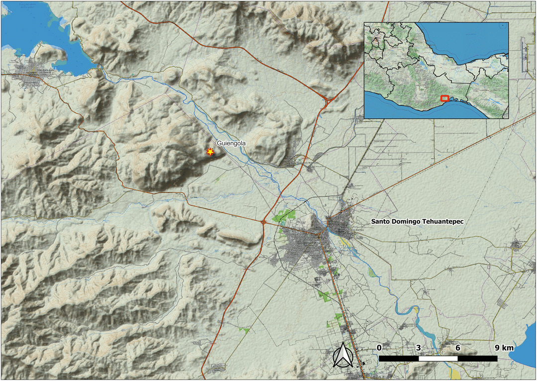
Dense subtropical dry forest and rugged terrain had limited earlier mapping efforts by researchers such as Edward Seler, Peterson and MacDougall, and Fernández Dávila. Those projects documented a ceremonial precinct with major temples but could not define the full settlement size. The Guiengola Archaeological Project addressed this by combining GPS-based surveys with a lidar scan that penetrated the canopy. Analysts identified 1,173 structures across the site. Intensive survey of 90 buildings, which averaged roughly 100 square meters, produced detailed plans and recovered 2,292 artifacts. Diagnostic ceramics, including fine gray pottery with zoomorphic supports and Mixteca-Puebla sherds, place occupation firmly in the Late Postclassic period (A.D. 1200–1521). No evidence of earlier settlement appears.
Urban Zones and Hierarchical Layout
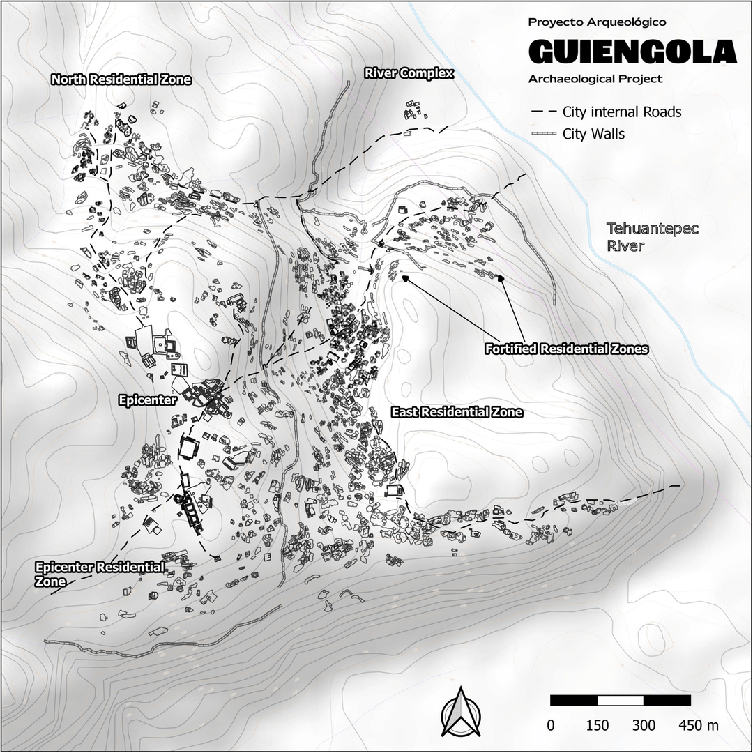
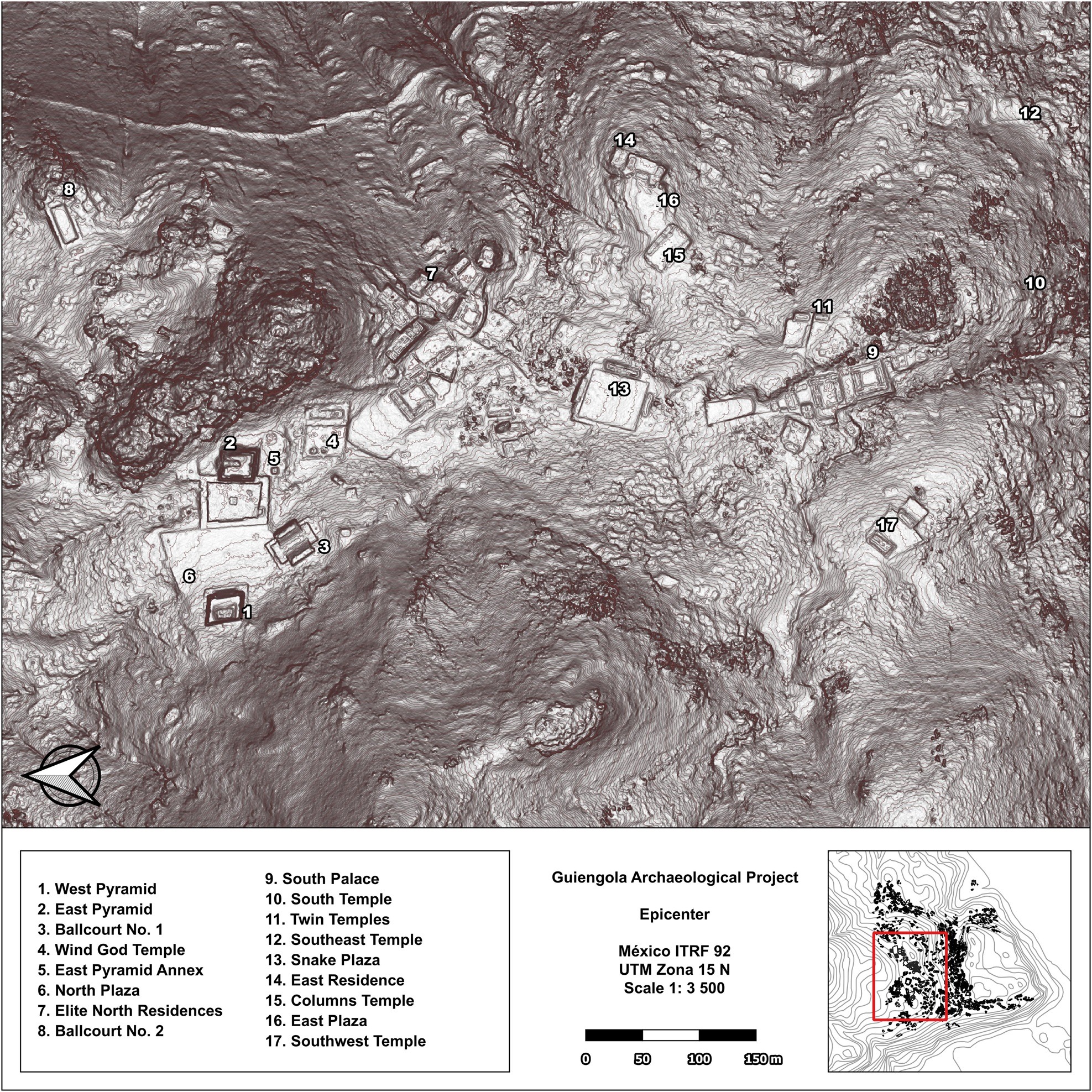
The resulting maps divide the city into distinct zones with different building densities and functions. The Epicenter occupies about 22.5 hectares on higher ground and holds the largest public structures. Including two ballcourts, three open plazas, and 15 elite residences among 104 total features. Walls enclose parts of this core on the east and south. North of the Epicenter, the North Elite Residences connect via roads to the Tehuantepec River, Snake Plaza, and a private ballcourt surrounded by cliffs. South of the core sits the South Palace Complex. Which is a 6,500-square-meter multi-patio residence with nine patios and 24 rooms, oriented along a northwest–southeast axis. Researchers interpret this complex as a multifunctional seat of government and elite residence, comparable in organization to Late Postclassic palaces at Yagul and Mitla.
Five residential zones extend north and east of the Epicenter, separated by walls and elevation changes. The East Residential Zone contains 501 structures over 46 hectares, including 14 small temples with associated plazas. Residences here often feature multiple patios and follow seasonal drainage patterns that also served as paths. The North Residential Zone shows lower density and simpler single-patio houses. Two Fortified Residential Zones occupy the northeast. They’re protected by high walls (some still standing 5 meters tall) and gates that control access from the river. Construction density varies systematically: roughly 10–11 structures per hectare in the East and Fortified zones, closer to 5–6 in northern areas, and lowest (about 4.6) in the Epicenter where buildings are largest.
Defensive Walls, Roads, and Circulation Control
Walls and gates form an integrated system that both protected the settlement and regulated internal movement. The main road enters from the Tehuantepec River, zigzags through the Fortified Residential Zones via guarded gates, crosses the East Residential Zone past large compounds, and climbs to the Epicenter through another gate. Square structures built into the walls suggest checkpoints. Natural features—cliffs, rock outcrops, and seasonal streams—complement the walls. Elite areas occupy higher, better-protected ground, while residential zones spread across lower slopes. This layout allowed elites to oversee circulation while commoners organized compounds along drainage lines that created natural boundaries.
Residential Patterns and Social Organization
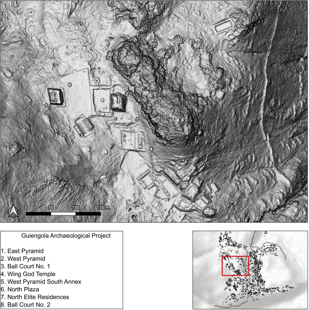
Differences in house form and density point to varied occupation histories and social distinctions. Multi-patio compounds in the East Residential Zone, such as Compound 237 with eight patios and 17 rooms plus an attached structure, appear to have grown over successive generations by adding rooms and courtyards. Simpler single-patio houses predominate in the North Residential Zone, which may reflect shorter occupation or different status. Clusters of residences around small plazas and temples outside the Epicenter indicate neighborhood-scale organization. These units resemble the yoho documented in early colonial Tehuantepec: extended family groups that managed their own compounds, shared public spaces, and contributed labor for larger projects. The city lacks a rigid grid; builders adapted construction to slopes, arroyos, and rock formations. Open plazas functioned as shared civic spaces amid the residences.
Comparisons to Other Mesoamerican Cities and Zapotec Sites
Guiengola shares features with other fortified Late Postclassic centers, notably Mayapan in Yucatan, where walls protected a migrant population in a contested landscape. Within Oaxaca, the South Palace Complex echoes the interconnected patios and restricted access of the Palace of the Six Patios at Yagul and the Church Group at Mitla. These parallels suggest shared elite architectural traditions linking Central Valley polities with the Isthmus. Broader Mesoamerican urban patterns appear in the combination of monumental cores, neighborhood temples, hierarchical residences, and engineered defenses. Unlike the planned grids of Teotihuacan or Tenochtitlan, Guiengola’s organic adaptation to mountainous terrain highlights local responses to topography and political needs.
Historical Context of Zapotec Expansion
Ethnohistoric accounts place initial Zapotec movement into the Isthmus around A.D. 1350 under Coqui Cocijoeza 11 Water of Zaachila, with further consolidation under later rulers. The Isthmus already held Chontal, Mixe, Zoque, and Huave populations. Guiengola’s scale and internal complexity indicate it served as more than a temporary garrison.
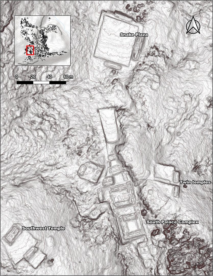
Labor invested in palaces, walls, roads, and residential compounds, plus evidence of continuous expansion, point to a political center that organized settlement and defense over generations. Traditional narratives emphasized elite decisions and treated accompanying populations as passive followers. Mapping of commoner neighborhoods shows active adaptation of living spaces and local organization of compounds, plazas, and temples.
In Conclusion
Lidar and survey data establish Guiengola as a hierarchically organized Late Postclassic city of 360 hectares rather than solely a fortress. The settlement includes a defended Epicenter with elite residences and public architecture, extensive residential zones with neighborhood-scale compounds, an internal road network, and walls that controlled both external access and internal movement. These features document social distinctions between elite and commoner areas, multi-generational household growth in some zones, and adaptation to the mountain landscape. The findings reframe Zapotec expansion into the Isthmus as a multi-generational process of colonization and urban construction, not a single elite-driven event. Recognition of Guiengola’s full urban character strengthens understanding of Late Postclassic political networks linking the Central Valleys, Sierra Sur, and Isthmus, and of how commoner groups shaped daily life and settlement organization before Spanish arrival.
