
Pairs of parallel grooves cut into Malta’s limestone bedrock have puzzled observers for centuries. Known as cart ruts, these features appear in dense clusters across Malta and Gozo. Their exact age has remained contested, with some scholars linking them to prehistoric Temple Period or Bronze Age activity and others placing them in the Phoenician, Punic, Roman, or Byzantine eras. A comprehensive new assessment of dating evidence settles much of this debate in favor of a Classical chronology for the majority of the tracks.
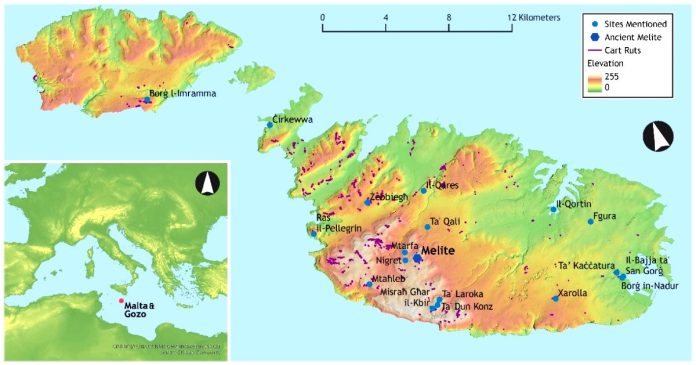
The research draws on the largest dataset assembled so far. It combines Structure-from-Motion models of 155 sites with digitised records from another 88, yielding 2628 distinct tracks totaling nearly 50 kilometres. These tracks were then compared against quarries, rock-cut tombs, agricultural trenches, and known urban remains.
Survey Scale and Morphological
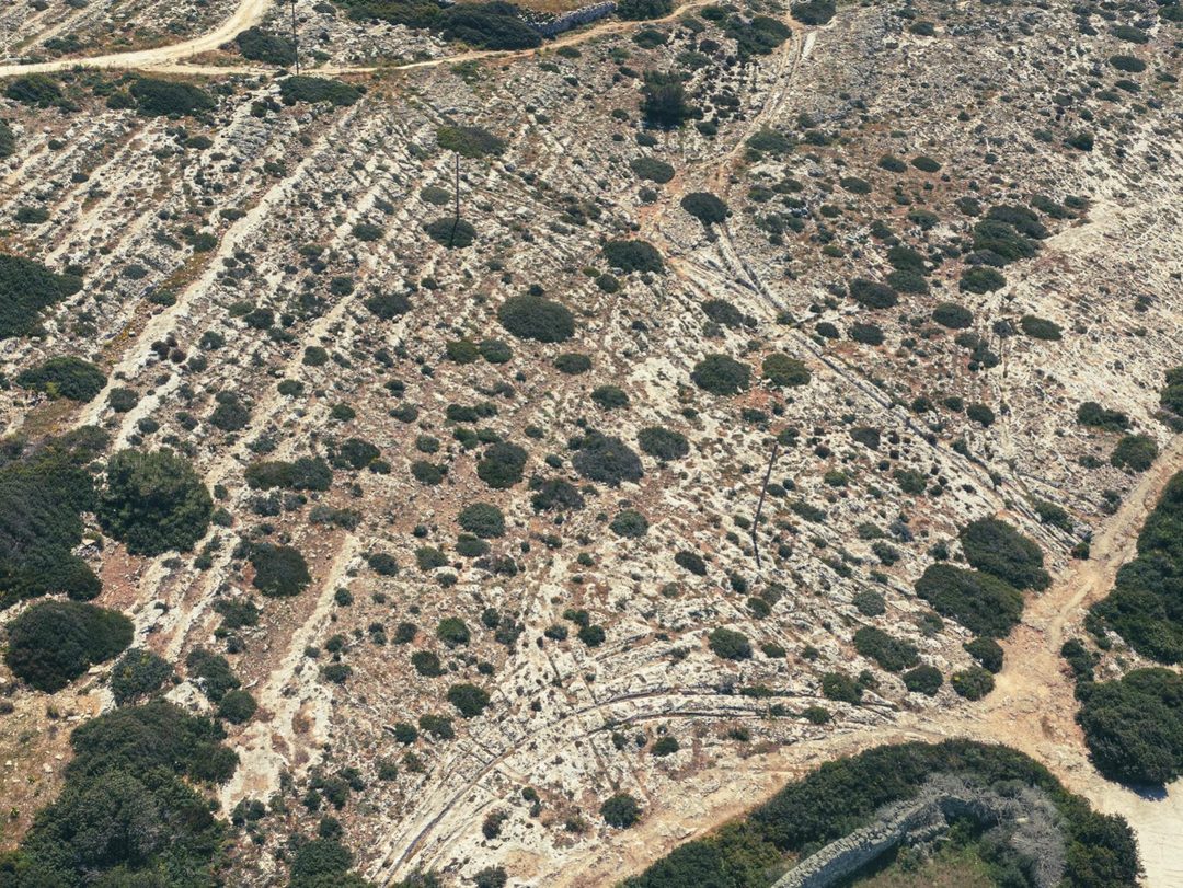
Researchers recorded cart ruts at 310 known sites on Malta, though many have been damaged or lost to modern development. Tracks range from isolated pairs to dense networks in which parallel lines merge and cross at sharp angles. The densest surviving concentration lies near Misraħ Għar il-Kbir, where dozens of overlapping pairs occupy an area of roughly 80 by 100 metres.
Modern cart ruts differ clearly from older examples. They display narrower gauges, wider individual grooves, and sharper breaks of slope. Most follow dry-stone walls or rural alleys that appear on late-nineteenth- and early-twentieth-century survey maps. Only 48 of the 2628 tracks meet these modern criteria. The remaining ancient tracks show broader gauges and more weathered profiles consistent with prolonged exposure.
Stratigraphic Links to Roman Structures

Direct stratigraphic relationships supply the strongest dating evidence. At the Domus Romana in Mdina, a pair of ruts runs along a street. Within the Roman urban fabric of Melite. Successive Roman road surfaces overlie the bedrock track. Establishing that the ruts themselves pre-date those later pavements and are unlikely to be earlier than the Phoenician or Punic period.
At il-Qortin in Marsa, eighteenth-century records document ruts worn into the threshold slabs of a large Roman warehouse or horreum. The building remained in use into the Byzantine period, and the ruts share its construction date. Similar associations appear at Melite’s southern perimeter, where multiple tracks converge on the line of the ancient ditch and possible city gates.
Quarries and Tombs Establish Relative Chronology

Cart tracks and Classical quarries interact repeatedly. At Ta’ Dun Konz and Ta’ Laroka, tracks cut through the floors of earlier quarries and are themselves truncated by later extraction phases. Block sizes and quarry morphology place the earlier phase in the Punic or early Roman period and the later phase in the late Roman or Byzantine period. Across the surveyed sites, 112 tracks are truncated by quarries and 17 are worn into quarry bases.

Rock-cut tombs provide additional termini ante quem. At least seven tracks are cut by Punic or Roman tombs. In each case the truncated track lies close to other surviving tracks, suggesting that traffic simply shifted to an adjacent route once the original one was abandoned. Tomb morphology evolved only gradually, so these relationships confirm a broad Classical date without pinpointing a single century.
Rural Landscape Patterns and Statistical Association
Recent development-led excavations reveal consistent spatial organisation in the Classical countryside. At Nigret near Rabat, cart ruts underlie and cut into a cobbled Roman road flanked by agricultural trenches and burials. Comparable patterns occur at Ta’ Qali, where multiple overlapping ruts were later filled and covered by successive paved surfaces. At Xarolla, where deep ruts pass between Roman tombs and hypogea. Agricultural trenches stop short of the tracks, indicating that the routes were already in place when fields were laid out.
A dataset of 1690 burial features across Malta shows a strong spatial correlation with the recorded tracks. The statistical mode of distance from tombs to the nearest track is 21 metres, and 34 percent of tombs lie within 50 metres. The observed distribution falls well outside the range expected from random placement, supporting the long-recognised Classical practice of roadside burial.
Evaluation of Earlier Prehistoric Arguments

Submerged ruts at San Ġorġ Bay in Birżebbuġa have often been cited as evidence of prehistoric date. Sea-level data indicate a rise of roughly 1.3 metres over the last two millennia, sufficient to leave the surviving grooves dry in the Roman period. Shifting beach sediments could also have allowed the track to continue across now-submerged ground. Intersections with Bronze Age silo pits appear to result from ruts worn into the openings rather than from pits cut through existing tracks.
Arguments based on soil erosion or cliff collapses likewise fail to require a prehistoric origin. Anthropogenic erosion continued through the Classical period, and documented rates of lateral spreading on Malta can exceed one centimetre per year. Truncation by rock-cut tombs or quarries therefore supplies only a relative date within the Classical sequence, not proof of an earlier period.
Formation Processes Consistent with Wheeled Traffic
The ruts are best explained as the cumulative wear of wheeled vehicles rather than as deliberately cut features. Roman carts commonly carried iron or copper-alloy tires. Experimental and observational data show that Maltese limestone can fail under the weight of a loaded wooden cart once the surface is wet, and metal tires would accelerate that process. The absence of clear hoof wear along the spines of ancient tracks matches the limited evidence for nailed horseshoes or hipposandals in the central Mediterranean.
Tracks formed through a shallow soil cover. Once a pair deepened and became difficult to use, traffic shifted laterally, producing the parallel clusters visible today. Abandoned surfaces then offered convenient locations for quarrying or roadside tombs.
Proposed Chronological Sequence
The available evidence supports the following sequence. Limited track formation may have begun in the late Bronze Age under conditions of growing settlement nucleation and Mediterranean exchange. Phoenician colonisation and subsequent intensification of agriculture and population expanded the network. Use peaked during the Roman centuries, when rural villas, olive and vine cultivation, and urban demand at Melite required extensive overland links to ports. After the Aghlabid conquest of 870 CE and associated depopulation, most routes fell out of use. A later resurgence of rural traffic under the Knights and British administration produced the morphologically distinct modern tracks still visible along certain alleys.
In Conclusion
The combined stratigraphic, contextual, and statistical evidence demonstrates that some Maltese cart ruts are conclusively Roman and that a Classical date accounts for the great majority of surviving tracks. No secure prehistoric example has yet been identified, although the possibility of limited earlier formation cannot be ruled out. Future radiometric dating of sediments filling or overlying excavated tracks would refine the chronology further. The ruts themselves remain the clearest physical record of the transport system that linked Classical Malta’s farms, quarries, cemeteries, and cities.
