
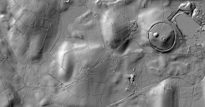
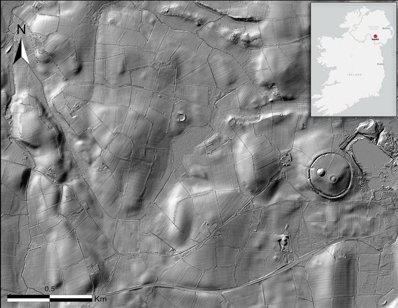
Around 1200 BC a substantial hillfort took shape on a prominent ridge in the Navan landscape of County Armagh. Known as Haugheys Fort, the site formed the core of an extensive complex that combined settlement, specialised craft work and formal ritual activity. New remote sensing, targeted excavation and archival study have redefined the scale and organisation of this place. The results place it among the most significant Late Bronze Age centers yet identified in Ireland or Britain.
The Scale of the Enclosures
Earlier work recorded three roughly concentric enclosures covering 9.29 hectares. The innermost measured a little over one hectare and consisted of a stone revetted bank inside a rock cut ditch 3.2 m wide and 2.8 m deep. Oak timber from the base of that ditch yielded a felling date of 1152 to 1116 BC.
Short lived wood and charcoal from the middle and outer ditches produced comparable dates. The study shows that the three circuits formed a single system built and used together between roughly 1150 and 1050 BC
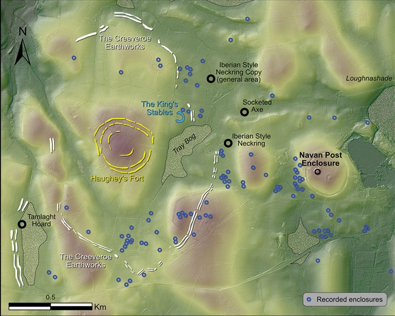
Lidar and gradiometry surveys have now shown that the outermost circuit is far larger. In addition, parallel ditches previously labelled the Creeveroe Earthworks form a continuous enclosure of 109 hectare that surrounds Haugheys Fort. In places the line ignores natural contours and incorporates the edge of Tray Bog. A possible southwestern annex may enclose the findspot of the Tamlaght hoard and would increase the total area still further. At this scale the site ranks among the three largest known hillforts in Ireland or Britain. Only Spinans Hill 2 in County Wicklow, at 131 hectares, is larger.
Settlement Density and Building Types
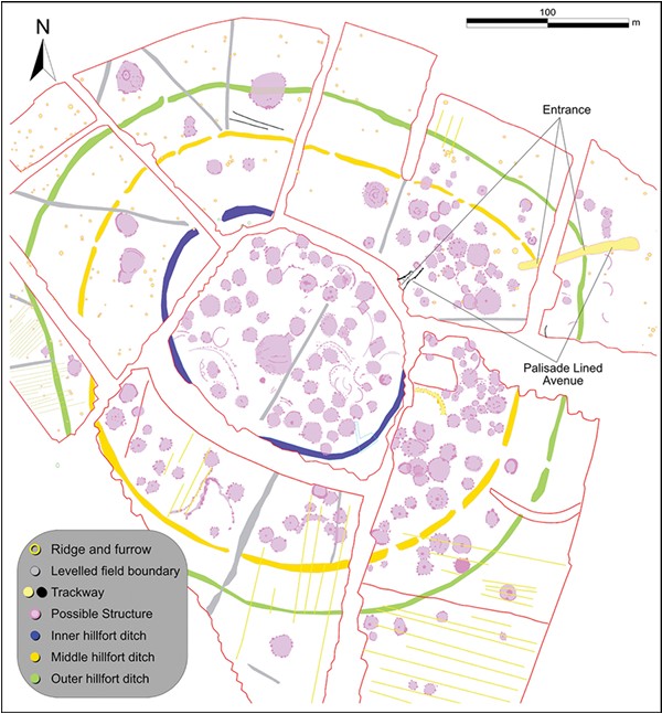
Magnetic gradiometry across the inner and middle enclosures revealed more than 204 discrete anomalies consistent with circular wooden buildings. Most measure 7 to 9 m in diameter, matching the size range of ordinary Bronze Age houses elsewhere in Ireland. Three structures stand out at 22 m, 23 m and 30 m. The largest occupies the central area where earlier excavation had already noted a substantial post-built building. Central post settings inside these larger structures indicate they were fully roofed. Their scale rules out domestic or workshop use; they functioned as communal or institutional buildings.
Many of the smaller houses appear arranged in loose rows. Intensive occupation traces, including pits, postholes and stakeholes, occur both inside the inner enclosure and immediately outside its north eastern entrance. Waterlogged ditch fills preserved large quantities of animal bone and cereal grain, pointing to a substantial resident population or to repeated large scale gatherings. Palaeoenvironmental data record widespread clearance of woodland around the hillfort in the same period, consistent with sustained human activity across the wider landscape.
Craft Production and Long Distance Exchange
Excavation inside Haugheys Fort recovered casting debris, fragments of bronze and gold objects, and waste from metal working. The hilltop produced no molds or crucibles. At the nearby Kings Stables pool, investigators did recover eighteen mold fragments for leaf‑shaped swords. The spatial separation implies specialized zones of production and deposition.
The Tamlaght hoard, found at the edge of a bog 500 m south west of the fort, contained a Fuchsstadt type bowl, a Jenišovice type cup, a Central European bronze ring and a leaf shaped sword. The two vessels are the only examples of their types known in Atlantic Europe. An Iberian style neck ring and a socketed axe were found just east of the Creeveroe circuit. Together these objects demonstrate that the community maintained contacts reaching into Iberia and across Central Europe while also producing high status metalwork of its own.
The Ceremonial Avenue and Ritual Pool
All three enclosures of Haugheys Fort open toward the north east. Geophysical survey traced an elaborate avenue 87 m long and 5 m wide that begins inside the middle enclosure, passes through the outer entrance and continues downhill for at least another 40 m. The surface was metalled and flanked by continuous palisades. Inside the inner enclosure a shorter, similarly defined corridor aligns with the same axis.
The avenue leads toward the Kings Stables, an artificial circular basin 25 m in diameter sunk 4 m below the surrounding ground and the water table. The basin filled rapidly with water after construction and remained permanently waterlogged. Deposits recovered from it include the sword moulds, partly articulated animal remains (especially dog and pig), red deer antler and the anterior portion of a human skull together with disarticulated ribs. The contrast with the ordinary domestic fauna from Haugheys Fort is sharp. The pool therefore appears to have functioned as a formal place of deposition and possibly sacrifice, linked to the hillfort by a purpose built processional route.
Organisation and Social Implications
The combination of dense settlement, specialised craft areas, monumental enclosure and formal ritual architecture indicates a high degree of coordination. Large numbers of people were required both to construct the 109 ha perimeter and to maintain the internal buildings and avenue. Burial monuments and metalwork deposits clustered along the outer boundary, especially near a probable southern entrance flanked by two large cairns. These placements suggest deliberate efforts to mark ancestral claims and to control movement into the complex.
Scholars still debate whether authority sat with permanent elites or emerged only during communal ritual. Across Ireland, the period otherwise shows a landscape of isolated, uniformly sized farmsteads. Haugheys Fort stands apart by its scale and internal differentiation. Comparable concentrations of houses occur at a handful of other Irish hilltop sites and at certain continental centers, yet few match the integrated package of production, residence and ceremony visible here.
Conclusion
Haugheys Fort, the Kings Stables and the expanded Creeveroe enclosure together formed a coherent Late Bronze Age complex. It’s of exceptional size and organizational sophistication. The site served as a regional focus for craft production. With long distance exchange and formal ritual activity. This long before the Iron Age monuments of Navan Fort rose on the neighboring hilltop. Its archaeology supplies one of the clearest demonstrations yet available of the capacity of Late Bronze Age communities in north west Europe to create large, specialized and enduring centres.
