
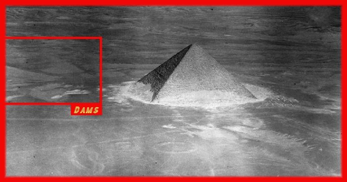
The Red Pyramid rises on the Dahshur plateau roughly 30 km south of Cairo. Built by King Snefru in the early Fourth Dynasty around 4,500 years before present. Two long linear structures cross the adjacent Wadi Dahshur a short distance to the southwest. For more than a century these features appeared on maps and aerial photographs yet received little systematic study. A new examination of satellite imagery, digital elevation models, historical cartography, and watershed data now identifies them as a pair of engineered dams accompanied by a diversion channel. The structures measure 600 to 700 m in length, anchor into both valley flanks, and display morphological traits consistent with water retention and flow regulation rather than stone transport.
Location and landscape setting
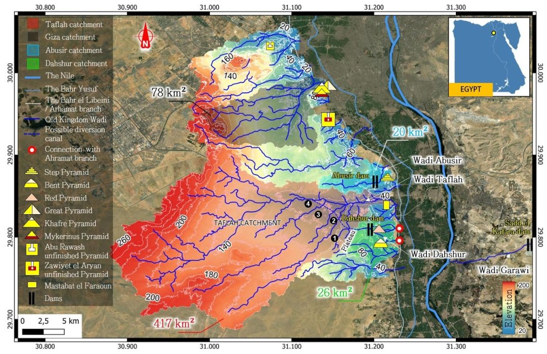
The Dahshur plateau forms a transitional zone between the Nile floodplain and the western desert. Wadi Dahshur provides an east west corridor that descends from the plateau toward Lake Dahshur at the foot of the escarpment. The valley floor drops from near 60 m above sea level to roughly 18 to 30 m over a distance of about 2 km, producing an average gradient of 1.5 to 2 percent. This slope favors gravity driven surface flow. Local sub catchments immediately around the pyramid drain only 4 to 7 km². The larger Wadi Taflah system lies immediately to the west and covers approximately 400 km², rising westward to elevations of 200 to 300 m. A flat drainage divide near 80 m above sea level separates the two systems and offers a natural route for limited water diversion.
Earlier maps and interpretations
In 1843 the German surveyor Georg Erbkam recorded the linear features on one of the earliest detailed maps of the region. A little more than a decade later, the Prussian expedition led by Karl Richard Lepsius mapped them again.
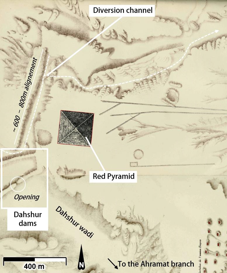
In 1897 the French Egyptologist Jacques de Morgan published a comprehensive survey of the Memphite necropolis that shows both embankments clearly, together with a channel running north of the Red Pyramid. Royal Air Force photographs taken in 1925 capture the same structures from the air.
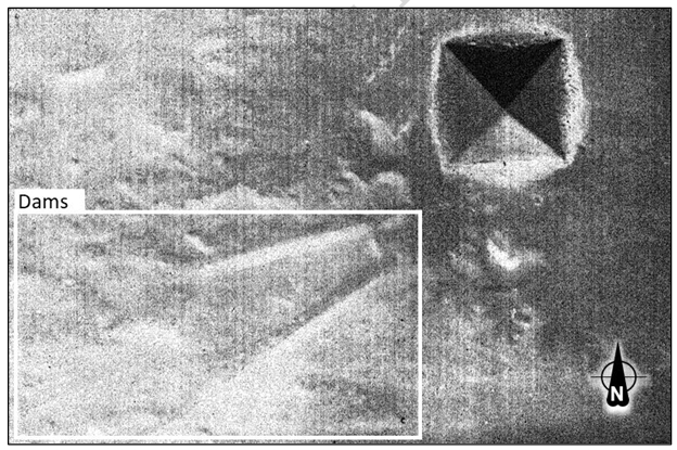
background (white rectangle) – coordinates: 29.80667, 31.20650 © UCL Institute of Archaeology.
Reproduced with permission. Image Source: https://doi.org/10.1038/s40494-026-02833-9
In 1947 the British archaeologist Leslie Grinsell described them as causeways that once linked western limestone quarries to the pyramid. The German Egyptologist Dieter Arnold later treated them as roads for moving core material, though he rejected the idea that they functioned as construction ramps. More recent landscape studies mapped the eastern feature as a transport ramp and the western one as a natural topographic rise. None of these accounts examined the structures as possible water control works.
Form of the embankments
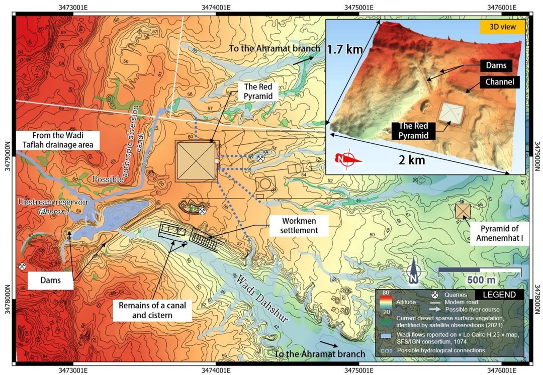
Digital elevation models derived from ALOS data and from the 1974 1:5000 topographic sheets of the Survey of Egypt provide the main geometric evidence. Each structure spans the full width of the wadi and rests against both valley walls. Basal thickness ranges from 15 to 30 meters. Preserved height reaches 6 to 7 meters above the present sand filled floor, though the original height may have been greater. Cross sections are broadly trapezoidal, matching the form of earth and rockfill embankments built to resist water pressure.
The western structure follows a zigzagging line that creates a triangular central section about 200 meters long along the crest. The opening angle measures 70 to 75 degrees. This plan matches a duckbill weir, a spillway form that lengthens the effective crest and therefore raises discharge capacity for any given head of water. The eastern structure shows a clear central depression that may represent an intentional outlet, an auxiliary spillway, or a later breach. The two dams stand only about 200 meters apart and enclose a small intermediate basin whose present volume is estimated at 230000 cubic meters; the true capacity before sand filled it could have been twice as large.
How the pair of dams worked
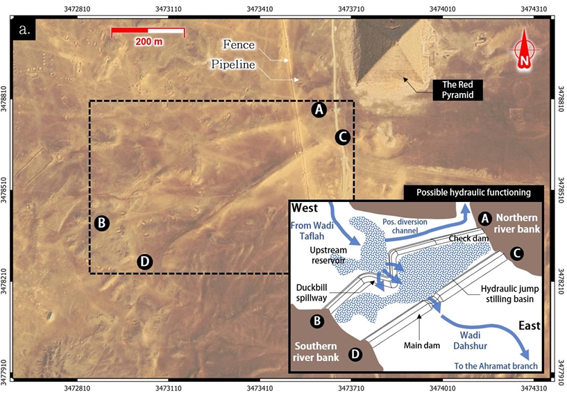
Two barriers placed so close together imply complementary roles. The upstream western dam most likely served as a check dam. Water slowing in its backwater would drop coarse sediment and suspended load, thereby protecting the lower reservoir and any linked canal from rapid siltation. The intermediate basin would also dissipate energy and reduce scour on the soft marly limestone of the plateau. The eastern dam then held the clearer water. Controlled release through the central depression or over the crest could feed either the lower wadi or the nearby diversion channel.
Capacity of the duckbill weir
Standard hydraulic equations give a rough sense of spillway performance. With an effective crest length of 200 meters and a discharge coefficient near 0.62, the weir can pass far more water than a straight crest of the same channel width. A 50 millimeter rainfall over the 3.2 square kilometer local catchment of Wadi Dahshur, assuming a 30 percent runoff coefficient, produces about 50000 cubic meters. Under a triangular hydrograph lasting one hour the peak discharge approaches 26 cubic meters per second, and the corresponding overflow depth remains modest, on the order of 0.2 meters. Even a limited share of runoff taken from the much larger Taflah basin could still pass without overtopping protected sections of the dam.
The diversion channel
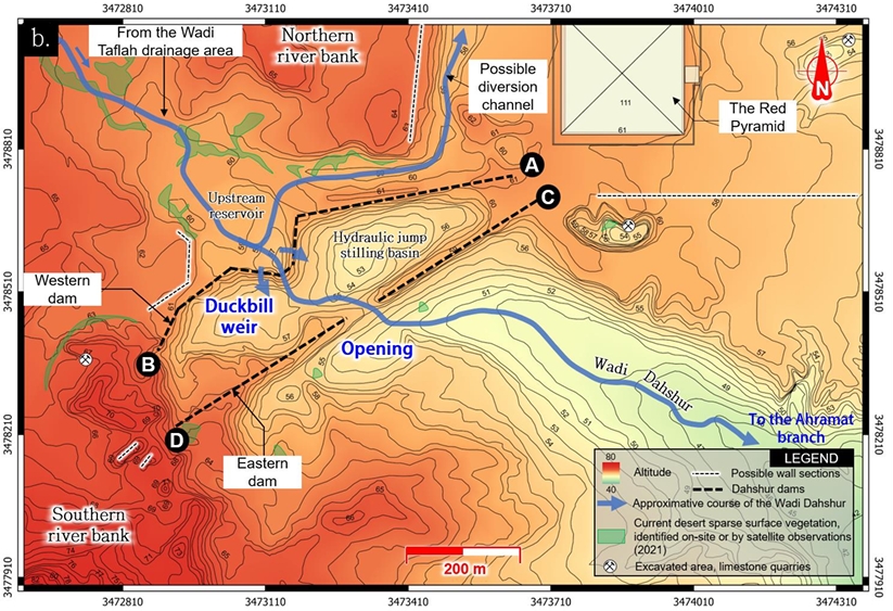
Jacques de Morgan’s map and later topographic sheets trace a regular channel that begins near the western dam, runs parallel to the west face of the Red Pyramid for 600 to 800 meters, then turns east and rejoins an ancient wadi bed after a total length of about one kilometer. The channel lies a few meters below the 60 meter contour and therefore sits roughly 40 meters above the Nile floodplain. Its straight alignment and nearness to the pyramid faces make it a clear target for future excavation. If the dams supplied it with steady flow, the channel could have held a stable water surface useful for moving loads by barge or water assisted sled once materials had been raised from the valley floor.
Climate and water supply
After the Green Sahara phase ended, rainfall across northern Egypt declined yet remained higher and more variable than today. Proxy records from Lake Qarun, Soreq Cave, and regional sediments point to annual precipitation on the order of 50 to 150 millimeters during the early Fourth Dynasty. Most of that rain fell in winter and was interrupted by occasional intense storms. Ordinary runoff coefficients of 1 to 3 percent could rise to 30 percent during flash floods. Under those conditions the local Wadi Dahshur catchment alone would have yielded several thousand cubic meters in a typical wet season. Diversion from even a fraction of the Taflah system could raise that volume by one or two orders of magnitude.
Possible use during construction
A controlled water supply so close to the Red Pyramid would have offered clear practical gains. Light barges or sleds floating on a canal only a few meters wide could move heavy loads across the plateau. Water would also have been available for mixing mortar, damping dust, and supplying the workforce. Rectangular installations found southeast of the dams have been read as workmen’s barracks, a pattern already known beside the Sadd el Kafara dam. After the pyramid was finished the same system could have fed seasonal irrigation or ceremonial needs farther north toward the Mastabat el Faraoun, which stands at a comparable elevation.
Relation to other early works
The Dahshur structures belong to a small group of large hydraulic installations known from the late Third and early Fourth Dynasties. The Sadd el Kafara dam across Wadi Garawi, built about 20 kilometers to the east, reached more than 14 meters in height and failed in a major flood, apparently because its spillway capacity was inadequate. The Gisr el Mudir at Saqqara and the Wall of the Crow at Giza likewise managed surface runoff on the desert edge. The high capacity duckbill weir at Dahshur may reflect a practical response to the limits shown by those earlier failures.
Limits of the evidence
Most of the site lies inside a restricted military zone. No excavation has ever taken place. Absolute dating of the embankments is still unavailable, so any link to the Red Pyramid rests on spatial association and regional context rather than radiometric proof. The exact character of the central depression on the eastern dam, the methods used to manage sediment, and the long term upkeep of the system cannot be settled without stratigraphic data. Future work should focus on the spillway zone, the intermediate basin, the diversion channel, and any remaining intake features along the 80 meter contour that divides Wadi Taflah from Wadi Dahshur.
The two linear structures that cross Wadi Dahshur show the scale, geometry, and landscape position of engineered dams working in series. Placed against the wetter conditions of the early Fourth Dynasty and the nearness of the Red Pyramid, they form a coherent system able to regulate episodic runoff, trap sediment, and deliver controlled water to a canal that passed within tens of meters of the monument. Confirmation of building methods and absolute date must wait for excavation, yet the morphological and hydrological evidence already ranks these features among the earliest large scale water management works tied to pyramid construction in Egypt.
