

Recent advances in remote sensing have transformed our understanding of precolumbian societies in the Amazon basin. What were once viewed as sparse and simple communities now emerge as creators of vast engineered landscapes. In the Upper Upano Valley of eastern Ecuador an airborne LiDAR survey conducted by the National Institute of Cultural Heritage mapped three hundred square kilometers and revealed thousands of earthworks. These features include extensive networks of roads and structured complexes that challenge earlier assumptions about Amazonian capabilities. The survey builds on decades of ground based research and provides a panoramic view of monumental construction dating primarily to the Upano cultural phase between roughly seven hundred BCE and five hundred or six hundred CE.
The Upano Valley and the Scale of Discovery
The Upano Valley lies in the Andean foothills at elevations between one thousand and fifteen hundred meters. It features a wide river channel flanked by steep barrancos and influenced by the active Sangay volcano. Earlier excavations at sites such as Wapula documented clusters of raised earth structures yet lacked a comprehensive regional picture. The LiDAR project changed that by penetrating dense vegetation and exposing previously unknown concentrations of features.
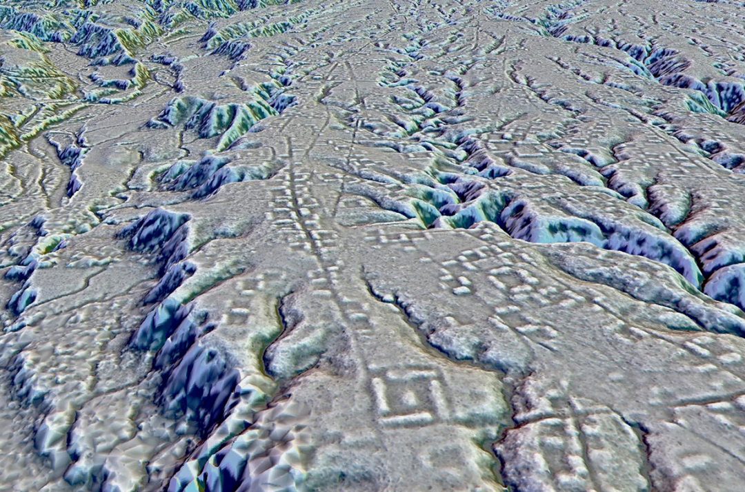
In total the survey identified nearly eight thousand anomalies across the study area. These include more than five thousand platforms along with truncated hills, plazas, and linear excavations. Researchers distinguished thirty settlements and ten larger macro settlements defined by high densities of structures and connecting infrastructure. One standout example is Kunguints a newly prominent center spanning several square kilometers with over one thousand structures and dense road networks. The known site of Wapula expanded dramatically in the data forming part of a longer corridor of activity along the river with neighboring areas such as Junguna and Jurumbuno.
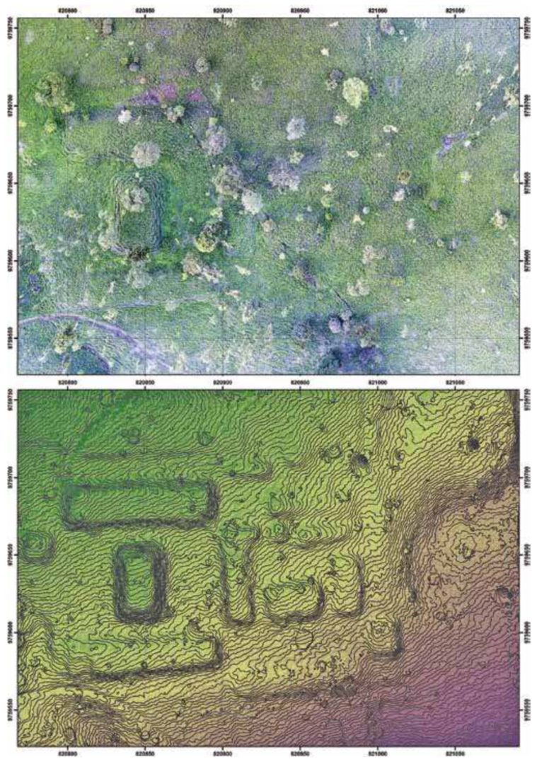
This scale indicates organized landscape modification on a regional level. Roads totaling around three hundred kilometers link complexes while ditches and canals suggest systems for drainage and possibly water management. The data align with observations from drone surveys at individual locations such as the Eden site where modular arrangements stand out clearly.
Geometric Pill Shaped Configurations Form and Variety
Among the most striking elements are the raised earth structures that dominate the Upano record. In this analysis these appear as geometric pill shaped configurations elongated rectangular forms with consistent proportions and often arranged in repeating patterns. Typical examples measure around twenty by ten meters at the base and rise two to four meters high. Larger variants exceed thirty meters in length while smaller ones fill in the spaces between them.
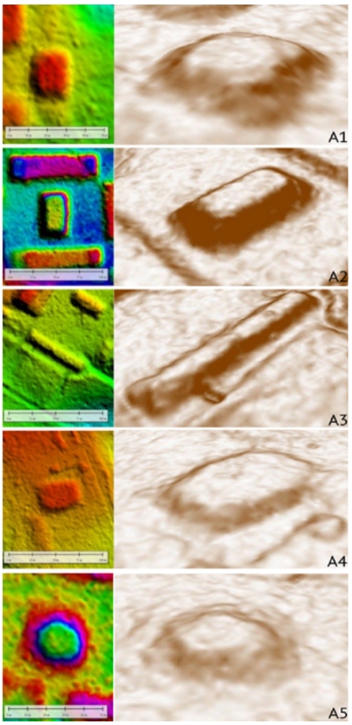
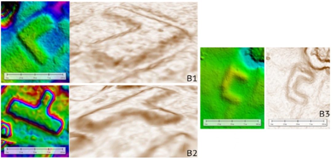
The LiDAR typology reveals considerable variety within these configurations. Simple forms include square rectangular elongated oval and irregular outlines. Composite versions combine elements into L T or U shapes. Multi level examples stack or step platforms creating terraced appearances. Many complexes follow a modular design with four platforms enclosing a central plaza sometimes featuring a taller platform in the middle. This layout repeats across sites and suggests deliberate planning rather than ad hoc building.
A Node Named Eden
At the Eden site for instance drone derived plans show precisely these geometric pill shaped configurations clustered around open spaces with connecting linear features. Similar patterns appear throughout the valley indicating a shared architectural vocabulary. Truncated natural hills were also modified by flattening summits and in some cases adding platforms on top. These hybrid forms blend human intent with existing topography.
The configurations served multiple roles. Excavations at Wapula and related sites uncovered hearths post holes and domestic debris on platform surfaces pointing to residential use. Burials in urns occur within the same contexts showing that daily life and mortuary practices overlapped. Plazas likely hosted communal activities while the overall layout facilitated movement and possibly social differentiation.
Construction Techniques and Landscape Engineering
Builders in the Upano Valley employed both additive and subtractive methods. Platforms often rose through the superposition of earth layers while roads and plazas resulted from deliberate excavation into the terrain. Material from ditches and cuts was frequently repurposed to form adjacent embankments or terraces. Volcanic tephra layers from Sangay eruptions sealed some Upano phase deposits around four hundred to six hundred CE providing chronological markers and evidence that volcanic events influenced site abandonment or shifts in occupation.
Linear features stand out as a major innovation. The extensive road networks connect individual complexes into larger systems and in places appear to continue between settlements. Ditches with V shaped profiles and associated embankments may have served drainage needs especially near rivers or in wetter zones. Some canals seem oriented toward agricultural fields though confirmation requires further field work.
These techniques demonstrate sophisticated understanding of local soils topography and hydrology. The resulting landscape supported sustained occupation in a region with high rainfall and volcanic risks. Population estimates remain tentative yet densities implied by the structures suggest communities far larger and more interconnected than once assumed.
Comparisons with Other Amazonian Earthworks
The Upano findings fit into a wider pattern of precolumbian earth construction across the Amazon. In the Llanos de Mojos of Bolivia large mounds known locally as lomas formed through long term accumulation of domestic debris. These tell like features supported platforms causeways and canals within a stratified society. Rich burials with exotic materials indicate social hierarchy while agricultural infrastructure sustained dense populations.
On Marajó Island at the Amazon mouth the Marajoara culture between four hundred and thirteen hundred CE built platform mounds on river levees. These structures rose above flood levels and incorporated fishponds created by earth extraction. Urn burials and domestic remains again point to integrated residential and ritual functions. Earlier occupations preceded the main mound building phase.
Similarities across regions include plaza centered layouts modified natural elevations and linear connections. Differences reflect local environments and cultural choices. The geometric pill shaped configurations of the Upano stand out for their modularity and repetition while Mojos and Marajó emphasize cumulative growth and hydraulic engineering. Together these cases illustrate diverse yet comparable strategies for shaping tropical landscapes.
Implications for Understanding Precolumbian Amazonian Societies
The earthworks overturn outdated views of Amazonian societies as small scale and environmentally constrained. Instead they reveal planned monumental construction connectivity through road systems and adaptation to challenging terrain. The geometric pill shaped configurations in particular embody a coherent design language repeated across macro settlements. This suggests shared cultural practices possibly linked to social organization or ceremonial needs.
Volcanic activity and seismic risks added complexity yet communities persisted and innovated for centuries. Later reoccupations after the main Upano phase indicate resilience and continuity. The data also raise questions about agricultural support systems and the role of plazas in community life.
Conclusion
The ancient earthworks of the Amazon particularly the geometric pill shaped configurations documented in the Upano Valley represent a remarkable chapter in human history. LiDAR surveys combined with targeted excavations have illuminated a landscape of thousands of structures connected by hundreds of kilometers of roads and organized into substantial settlements. These features comparable in ingenuity to earthworks elsewhere in the basin demonstrate planning engineering skill and social complexity in a tropical forest setting.
Far from passive inhabitants of the rainforest precolumbian peoples actively transformed their environment on a grand scale. Sites such as Eden Wapula and Kunguints stand as testaments to this legacy. Continued research including ground verification and chronological refinement will deepen appreciation of these achievements and their place in the broader story of Amazonian civilizations. The geometric pill shaped configurations offer a tangible window into worlds that thrived long before European contact and invite ongoing exploration of their meanings and connections.